Best Marine GPS Chartplotter: Top Picks for Coastal Navigation and Fishfinding
Finding the right marine GPS chartplotter can dramatically improve navigation, safety, and fishing efficiency. This guide highlights five top options that balance screen clarity, chart detail, sonar capabilities, and value. Each model pairs reliable electronics with modern displays and preloaded or compatible charts to help you plan routes, mark waypoints, and interpret underwater structure. Below you’ll find concise product highlights and a buying guide to compare standout features across popular options.
| Product | Brand | Main Strength | Display | Chart/Sonar |
|---|---|---|---|---|
| Simrad GO9 XSE | Simrad | Multifunction display with Active Imaging | 9″ touchscreen | Active Imaging, C-MAP Discover |
| Garmin ECHOMAP UHD2 94sv | Garmin | Integrated Navionics+ coastal charts | 9″ touchscreen | CHIRP, ClearVü, SideVü |
| Garmin ECHOMAP UHD2 54CV | Garmin | Compact full-function chartplotter | 5″ display | CHIRP traditional, ClearVü |
| Garmin ECHOMAP UHD2 74sv | Garmin | Balanced feature set for small to mid boats | 7″ touchscreen | CHIRP, ClearVü, Navionics+ |
| Garmin STRIKER 5CV | Garmin | Budget-friendly with built-in maps | 5″ display | CHIRP traditional and ClearVü |
Simrad GO9 XSE With Active Imaging

Simrad GO9 XSE combines a 9-inch color touchscreen display with a versatile multifunction platform. It serves as a powerful navigation hub, capable of GPS plotting, sonar support, and radar integration for larger boats or fleets. The included Active Imaging 3-in-1 transducer delivers CHIRP, SideScan, and DownScan imaging for detailed views of structures, cover, and fish near the seabed. The preloaded C-MAP Discover chart card offers high-resolution vector charts and coverage across US waters, with features like tides, currents, and depth shading to aid in route planning and fishing strategy. This unit is designed for sportboats, center-consoles, and smaller cruisers seeking a comprehensive display with expansion potential.
Key features to note include a bright, touch-first interface for intuitive control, a robust transducer that enhances fishfinding detail, and flexible chart options that support smart routing and marine navigation. The GO9 XSE can be configured with additional sensors and networked devices, making it suitable for boaters who want a scalable chartplotter that grows with their needs. For serious anglers and coastal navigators, it delivers a balanced blend of clarity, data, and expandability.
Garmin ECHOMAP UHD2 94sv With GT56 Transducer

The Garmin ECHOMAP UHD2 94sv pairs a bright 9-inch touchscreen with high-contrast detail for easy readability in sunlight. The included GT56 transducer supports Garmin’s traditional CHIRP sonar and advanced scanning options like ClearVü and SideVü, providing crisp images of structures and fish. This model integrates built-in Navionics+ coastal charts, which combine detailed coastal data with additional Navionics layers for improved depth, tides, and routing. The unit is well-suited for coastal navigation where accurate chart data and comprehensive sonar views are essential for fishing and safe passagemaking.
Users benefit from a straightforward interface, broad chart coverage, and reliable sonar imaging that helps identify fish-holding structures and underwater contours. The UHD2 94sv is a strong choice for anglers who want a capable, ready-to-ship chartplotter with reputable Garmin chart data and a responsive display, especially for boaters who navigate coastal zones frequently.
Garmin ECHOMAP UHD2 54CV Chartplotter

The 54CV model offers a compact 5-inch display with the same CHIRP traditional and ClearVü sonar benefits found in larger UHD2 players. It provides bright visuals and high-contrast color palettes that improve underwater readability, making it easier to distinguish fish, cover, and structures in varying light conditions. Built-in Navionics+ coastal charts deliver reliable navigation data, while the smaller footprint makes it a practical option for tighter spaces, smaller boats, or as a secondary display on larger vessels. This unit emphasizes portability without sacrificing essential chartplotter functions for inland and near-coastal use.
Garmin ECHOMAP UHD2 74sv With GT54 Transducer

The 74sv version provides a 7-inch daylight-readable touchscreen and the same robust CHIRP sonar technology, including ClearVü and SideVü scanning options. The GT54 transducer supports traditional CHIRP sonar, enabling clearer displays of fish and underwater structure. Navionics+ coastal charts come built-in, offering strong data for coastal routes, harbor approaches, and nearshore fishing. This model strikes a solid balance between screen size, sonar performance, and chart availability, suited for mid-sized boats or those prioritizing a larger display than the 54CV but without stepping up to larger units.
Garmin ECHOMAP UHD2 73sv With GT54 Transducer
The 73sv mirrors the 74sv’s feature set but emphasizes inland compatibility with Garmin Navionics+ inland data coverage. The 7-inch touchscreen remains bright and responsive, and the GT54 transducer provides traditional CHIRP plus ClearVü and SideVü scanning. Inland maps cover more than 18,000 lakes with detailed contour lines, enabling precise depth awareness and waypoint planning on large freshwater systems. This variant is ideal for boaters who navigate a mix of coastal and inland waterways and want an adaptable display with robust mapping.
Garmin STRIKER 5CV With Transducer
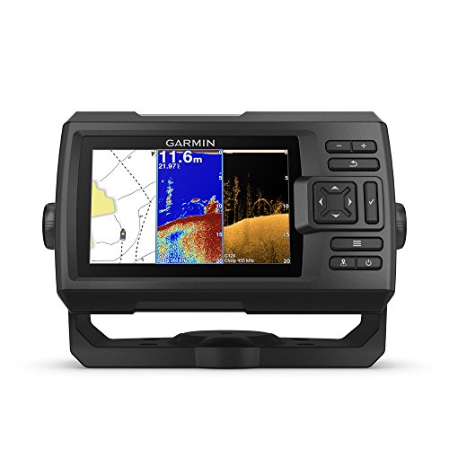
The STRIKER 5CV is a compact, budget-friendly option that includes a CHIRP traditional sonar and ClearVü scanning sonar for dual-perspective underwater views. It ships with a 5-inch display that remains legible in daylight and weather conditions, offering built-in Quickdraw Contours mapping software for user-generated lake maps with 1-foot contours over large outdoor areas. While it is basic compared with UHD2 models, it delivers essential navigation, waypoint marking, and route creation without requiring additional accessories. It is well-suited to smaller boats, kayaks, or anglers seeking a straightforward, cost-conscious chartplotter with decent mapping and sonar clarity.
Buying Guide: Key Purchase Considerations
When evaluating marine chartplotters, consider screen size versus boat space, chart coverage, sonar capabilities, and expandability. Here are several angles to help you compare models:
- Display and readability: Larger, high-contrast screens improve daylight legibility and allow more data to be displayed at once. If you fish or navigate in bright conditions, prioritize models with glare-resistant panels and better viewing angles.
- Chart data: Built-in coastal and inland charts, or compatibility with Navionics, C-MAP, or other chart providers, influence route precision and depth-aware planning. Preloaded charts simplify initial setup, while expandable chart libraries offer long-term versatility.
- Sonar capabilities: CHIRP traditional sonar is standard, but advanced models include SideVü, ClearVü, and DownScan Imaging. Active Imaging and multi-frequency transducers increase target detail and structure discrimination, aiding both fishing and navigation.
- Transducer options: Transducer type (plastic or bronze, through-hull, transom) affects signal strength and installation considerations. Confirm compatibility with your hull, boat size, and mounting preferences.
- Networking and add-ons: Many units support radar, autopilot integration, network sharing, and multiple displays. If you plan a multi-screen setup or future sensor upgrades, choose a system with easy expansion paths.
- Ease of use and interfaces: Intuitive menus, responsive touchscreens, and reliable GPS reception are critical for quick decision-making during trips or fishing sessions.
- Power, mounting, and installation: Ensure the unit’s power requirements and mounting footprint fit your dash layout and electrical system. Some models offer wireless updates and mobile app connectivity for convenience.
- Inland versus coastal needs: Inland-focused charts prioritize lake contours and inland maps, while coastal models emphasize tidal data, harbor approaches, and nearshore depth shading. Choose based on your typical waters.
Overall, the best marine GPS chartplotter balances display clarity, chart depth, and sonar performance with your boat size, typical waterway, and fishing style. For coastal navigation and general fishing efficiency, models with NAVIONICS+ or C-MAP Discover data and robust CHIRP or Active Imaging features provide the strongest value. For compact or budget-minded setups, smaller displays with Core CHIRP and ClearVü still deliver dependable navigation and fishfinding capabilities.